Files
geopandas/doc/source/gallery/spatial_joins.ipynb
T
Martin Fleischmann ed68a95033 DOC: debug readthedocs and nbsphinx (#1838)
* don't execute

* list examples

* try with executed notebooks

* build intro, add pygeos

* auto build

* build the same as currently

* remove kernel name

* add few more

* revert choro

* add rest

* remove kernelspec

* clear choropleths

* build choropleths, clear choro_legends

* clear introduction

* remove kernelspec

* clean meta

* execute choro_legends

* always execute + exceptions

* fix cartopy plot
2021-02-19 23:44:26 +00:00

7.5 KiB

Spatial Joins

A spatial join uses binary predicates such as intersects and crosses to combine two GeoDataFrames based on the spatial relationship between their geometries.

A common use case might be a spatial join between a point layer and a polygon layer where you want to retain the point geometries and grab the attributes of the intersecting polygons.
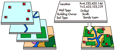
illustration

Types of spatial joins

We currently support the following methods of spatial joins. We refer to the left_df and right_df which are the correspond to the two dataframes passed in as args.

Left outer join

In a LEFT OUTER JOIN (how='left'), we keep all rows from the left and duplicate them if necessary to represent multiple hits between the two dataframes. We retain attributes of the right if they intersect and lose right rows that don't intersect. A left outer join implies that we are interested in retaining the geometries of the left.

This is equivalent to the PostGIS query:

SELECT pts.geom, pts.id as ptid, polys.id as polyid  
FROM pts
LEFT OUTER JOIN polys
ON ST_Intersects(pts.geom, polys.geom);

                    geom                    | ptid | polyid 
--------------------------------------------+------+--------
 010100000040A9FBF2D88AD03F349CD47D796CE9BF |    4 |     10
 010100000048EABE3CB622D8BFA8FBF2D88AA0E9BF |    3 |     10
 010100000048EABE3CB622D8BFA8FBF2D88AA0E9BF |    3 |     20
 0101000000F0D88AA0E1A4EEBF7052F7E5B115E9BF |    2 |     20
 0101000000818693BA2F8FF7BF4ADD97C75604E9BF |    1 |       
(5 rows)

Right outer join

In a RIGHT OUTER JOIN (how='right'), we keep all rows from the right and duplicate them if necessary to represent multiple hits between the two dataframes. We retain attributes of the left if they intersect and lose left rows that don't intersect. A right outer join implies that we are interested in retaining the geometries of the right.

This is equivalent to the PostGIS query:

SELECT polys.geom, pts.id as ptid, polys.id as polyid  
FROM pts
RIGHT OUTER JOIN polys
ON ST_Intersects(pts.geom, polys.geom);

  geom    | ptid | polyid 
----------+------+--------
 01...9BF |    4 |     10
 01...9BF |    3 |     10
 02...7BF |    3 |     20
 02...7BF |    2 |     20
 00...5BF |      |     30
(5 rows)

Inner join

In an INNER JOIN (how='inner'), we keep rows from the right and left only where their binary predicate is True. We duplicate them if necessary to represent multiple hits between the two dataframes. We retain attributes of the right and left only if they intersect and lose all rows that do not. An inner join implies that we are interested in retaining the geometries of the left.

This is equivalent to the PostGIS query:

SELECT pts.geom, pts.id as ptid, polys.id as polyid  
FROM pts
INNER JOIN polys
ON ST_Intersects(pts.geom, polys.geom);

                    geom                    | ptid | polyid 
--------------------------------------------+------+--------
 010100000040A9FBF2D88AD03F349CD47D796CE9BF |    4 |     10
 010100000048EABE3CB622D8BFA8FBF2D88AA0E9BF |    3 |     10
 010100000048EABE3CB622D8BFA8FBF2D88AA0E9BF |    3 |     20
 0101000000F0D88AA0E1A4EEBF7052F7E5B115E9BF |    2 |     20
(4 rows) 

Spatial Joins between two GeoDataFrames

Let's take a look at how we'd implement these using GeoPandas. First, load up the NYC test data into GeoDataFrames:

In [ ]:
%matplotlib inline
from shapely.geometry import Point
from geopandas import datasets, GeoDataFrame, read_file
from geopandas.tools import overlay

# NYC Boros
zippath = datasets.get_path('nybb')
polydf = read_file(zippath)

# Generate some points
b = [int(x) for x in polydf.total_bounds]
N = 8
pointdf = GeoDataFrame([
    {'geometry': Point(x, y), 'value1': x + y, 'value2': x - y}
    for x, y in zip(range(b[0], b[2], int((b[2] - b[0]) / N)),
                    range(b[1], b[3], int((b[3] - b[1]) / N)))])

# Make sure they're using the same projection reference
pointdf.crs = polydf.crs
In [ ]:
pointdf
In [ ]:
polydf
In [ ]:
pointdf.plot()
In [ ]:
polydf.plot()

Joins

In [ ]:
from geopandas.tools import sjoin
join_left_df = sjoin(pointdf, polydf, how="left")
join_left_df
# Note the NaNs where the point did not intersect a boro
In [ ]:
join_right_df = sjoin(pointdf, polydf, how="right")
join_right_df
# Note Staten Island is repeated
In [ ]:
join_inner_df = sjoin(pointdf, polydf, how="inner")
join_inner_df
# Note the lack of NaNs; dropped anything that didn't intersect

We're not limited to using the intersection binary predicate. Any of the Shapely geometry methods that return a Boolean can be used by specifying the op kwarg.

In [ ]:
sjoin(pointdf, polydf, how="left", op="within")
